Lago Chungara to Uyuni (northern Chilean hotsprings route and crossing the salares)
13/8/10 to 24/8/10 483km
Well, what a difference it made to be in Chile! The strong westerly winds had still been there when we set off from Tambo Quemado making the climb up to the border a hard slog, but at least we could ride our bikes for the most part, unlike during the galeforce winds of the day before when we walked for 10km and exhausted sought shelter in a new hospital building for the night.

At 4600m, ‘Bienvenidos a Chile!’ said the sign at the pass. ‘Chile’ by name, and very ‘chilly’ by nature! With the wind still blowing strong we pedalled hard downhill to Lago Chungara and the Chilean customs (actually all border formalities for Bolivia and Chile were done here) where the efficient but also very friendly quarantine staff with x-ray machines promptly relieved us of our figs and sultanas “but it’s not fresh fruit” we protested, “no, but it falls under the ‘etc’ category” they replied. Well Anna not to be outdone, (or to lose our valuable goods) managed to sneak a bag of sultanas through... “porridge just isn’t the same without them”. (Chile has very strict quarantine laws about fresh fruit, vegetables, dairy and meat products, but we weren’t going to be going past any shops or towns to stock up for the next 6 days or so). Otherwise a very smooth and quiet entry into Chile.
And probably the most spectacular border crossing we have seen!...On the shores of beautiful Lago Chungara at 4500m one of the highest bodies of water in the world, chilean flamingos were feeding in the semi frozen water alongside giant coots beneath a backdrop of pastel coloured red, orange to cream volcanic peaks. In the other direction the near perfect snow capped cone of Volcan Parinacota reflected in the lake.


We had planned on finding a wild camp on the lake shore somewhere but after we dropped into the Lauca National Park office and had a nice chat with Patricio the ‘guardaparque’, we opted for a night indoors the refugio with a bed and warm fire...
It ended up being a great night of intelligent conversation with Patricio’s friends, over chilean wine and a warm fire we talked about Chile, the environment, and politics. It was like being home, surrounded by ‘green’ friends who work in the environmental field, talking passionately about their land and their country. We had been plucked out of Bolivia and latin america as we know it with its disregard for environmental protection, and into the first world of Chile, among educated people who actually care about the future state of their environment whether it be related to the damming of rivers in Patagonia or the mining of borax in a national park. Our spirits rose with this interaction.

The CONAF crew at Chungara Refugio Rosi, Jimena, Pablo, Mara, Patricio, Ali and Anna
Northern Chilean hotsprings route
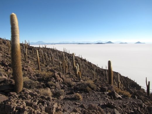
It was a spectacular 5 days riding through two national parks (Lauca and Isluga), the Reserva de Las Vicunas and the Salar de Surire National Monument, 3 hotsprings, and through some of the most spectacular volcanic altiplano we have ever seen especially around Lago Chungara and the Salar de Surire.
(*we followed the description of this route and online mudmap from the dutch cyclists Iris and Tore www.irisentoreopreis.nl which has water points, guardaparques etc. I have also written this part of the story with other cyclists in mind. **No fees are charged for entering any of the National Parks or reserves or hotsprings but the refugios charge between 4500 - 5000 Chilean pesos per person)
Day 1 Refugio Chungara to Termas Churigualla 17km
A short day after a midday getaway from the refugio. We rode back to Chilean customs then the sandy track to the right climbing 150m or so to a small pass before a steep descent to the ‘Termas Churigaulla’, where we camped on the other side of the river from the concrete bath complex among the spinifex. Plenty of Vicunas around here and a spectacular backdrop of the smoking Volcan Guallatire. Nice hot baths at 40 degrees.

Day 2 Termas Churigualla to Puente Rio Lauca 44km

Some nervous vicuñas watching us pass by under the smoking Volcan Gaullatire
We had heard that when we joined the main road the conditions would improve because the road is maintained by Quiborax, the company that extracts borax from the Salar de Surire and more than 100 trucks ply the road every day between Surire and the highway for Arica. Well the road was wide but it’s condition was atrocious with deep washboard, loose gravel and the trucks passing at regular intervals coating us in a cloud of fine dust. Riding through spectacular scenery, but the trucks took away some of the enjoyment.

Anna getting a coating of dust
In Guallatire the gaurdaparque was closed as we had suspected but we
could get water from a tap in front of the church and a friendly lady
from the hostal sold us some fresh vegetables which for us was an
amazing luxury, fresh tomatoes, avocado and potato...we would eat like
kings for the next two days!

Found a nice wild camp near the puente Rio Lauca away from the road
among the spinifex, cream sandstone hills and vicuna paths with views
back to Volcan Parinacota and Volcan Guallatire. Our coldest night in
Chile...-10 deg c in the vestibule of the tent at 6am (outside the
tent...?).
(*Gaullatire had an albergue with a restaurant, water, a Guardaparque
(when they are open!) and the hostal owner sold us some fresh veggies)
Day 3 Puente Rio Lauca to Termas de Polloquere 59km
A long day in the sand and washboard but being Sunday, the ‘day of rest’ no Borax trucks so a much nicer day on the road to Surire. The guardaparque in Surire was also closed but there was also no tap to get water outside. Luckily for us a nice clean stream ran in the ‘bofedale’ (spring fed meadow) alongside the guardaparque so we were still able to fill up for the next days on fresh clean water and ride on around the southern shore of the Salar de Surire towards another hotspring.
We had misread the map thinking that it was only 10.5 clicks from the guardaparque to Termas de Polloquere, so at the end of an already long day we came to another road junction...still 10 more to go! Just after that point I realised that the full 1L fuel bottle that i had strapped to the side of my rear pannier to accomodate the 10L water bag was missing... “oh no!...this could be a disaster. that’s our cooking fuel for the next 3 to 4 days!”. We had just crossed a steep creek crossing only 1km back, so a quick backtrack into the strengthening wind and luckily there it was, still sitting in the sand waiting for us!

We arrived at the Termas de Polloquere with a strong wind blowing...a spectacular natural thermal pool on the edge of the salar with a thick cloud of sulfurous steam rising from it. 43 degree water, a rock corral to camp behind sheltered from the wind complete with picnic benches, flamingos feeding and all surrounded by red orange volcanic peaks. Some sort of sulfur paradise!
Day 4 ‘Paradise lost, and then paradise regained’ (rest day at Termas de Polloquere)
We had decided to take a rest day at the hotsprings, we had hauled plenty of water from Surire and it was an absolute paradise to soak, rest, explore and enjoy the amazing setting.

However that paradise was lost when the first of six jeeploads of tourists arrived, parking around our campspot/picnic area for lunch, to snap some photos, and dip their toes in the water.
It is a hard thing to deal with when you have ridden 3 days of extreme roads with wind, washboard, trucks, and dust to arrive at such a beautiful remote and isolated hotspring paradise, only for it to be shattered by a number of tour groups ‘doing it easy’. But to be fair the French group, especially Francois were a friendly bunch and they offered us fresh food and their leftovers including tuna, tomatoes, salad, coca cola and bread.
Paradise was soon regained when the jeeps and vans left and we could enjoy the late afternoon and evening next to the steaming hot thermal baths by ourselves once again. Importantly with some fresh ingredients and bellies full of fresh food.

Enjoying a sunset bath in the Termas Polloquere...a sulfur paradise!
Day 5 Termas de Polloquere to Chinchillani llama dip 33km

A steep and sandy climb away from the Salar over ‘Cerro Capitan’ and into Bolivian territory past an uncleared but fenced off minefield from a time when these countries didn’t get along so well! Then 3km downhill and back into Chile, no customs, nothing, in fact strange that this road even goes into Bolivia for 3km...maybe for smuggling goods, who knows?
A short day, I was feeling a bit short of energy (we have been a bit low on food for this stretch and my expensive food hungry engine was suffering!) so we called it quits at a warm water river with a llama dip corral 3km from the mainroad on the way to Chinchillani. The stone llamacorral provided a bit of protection from the afternoon wind and while the water was not so warm as to warrant a swim, it was great for doing our laundry.
Day 6 Chinchillani llama dip to Pisiga via Enquelga, Isluga and Coclchane 49km
After riding through some spectacular red rock canyon country, and some narrow canyons we arrived in the windswept sandy village of Enquelga with its paved stone streets, a small tienda selling crackers, cookies and sardines and women weaving behind wind shelters. Apparently the Guardaparque for Parque Nacional Isluga was here, but we didn’t see any sign of it...not that it would be open anyway!
The final hotsprings of the route are 1km beyond the village of Enquelga but despite having some rundown shelters and picnic table (and its associated rubbish) the water was only luke warm and after Termas Polloquere it was a bit disappointing, so we didn’t venture in...oh well, 3 from 4 on the hotsprings route wasn’t so bad!
Back onto the paved (but in bad conditon) road for the last few clicks east to Colchane and the border with Bolivia. At least it felt different to the 200km or so of washboard we had just ridden!
(*Not too much going on in Colchane either, but a new hotel ‘Hotel Isluga’ had reasonable meals, a tienda with drinks and chocolate bars, and good internet at 1000CP an hour. Pisiga on the Bolivian side had many very basic alojamientos (seems that showering here is very optional!) but Hostal Bolivar was cheap, nice, friendly and even hot showers! There are a number of small shops here and a windswept outdoor ‘market’ with fruit and veggies even)
Crossing the Salares Coipasa and Uyuni
We had been fearing the section a little bit between Pisiga and Llica and crossing the Salar de Coipasa for the sole fact that there are no good maps of the area and we don’t carry a gps. So piecing together three different online sources of information (Jeff Kruys, vagamundo and Iris en Tore) and the good old fashioned ‘ask the locals’ approach, especially the llama herder on a motorbike who knew the route we were talking about and confirmed some of the things we had read about. We negotiated the 20km of sandy tracks heading east from Pisiga to access the Salar de Coipasa with a minimum of fuss...so far so good.

And there we were riding on our first salar aiming just east of an obvious island in the south and keeping the large island of coipasa and the salt works to our left...shimmering diamonds on the surface, floating islands, hexagonal ridges, salt works, smuggling trucks levitating in the distance over the white expanse and pools of water and wet salt which kicked up and stuck to the undercarriage of our steeds... “ouch, that’s going to take some cleaning!”
It was only a short time riding on the expanse of salt, 23km until we felt that we should head landwards to the red petrified coral rock and giant cactus to pick up the obvious, but also very sandy ‘main’ road Llica.

Camping out on the saltbush plain 6 km before Hizo in between the salares on the road to Llica. A scene reminiscent of of the Nullabor Plain - big skies, big cloud formations, low grey saltbush, so flat you could see the curve of the earths surface, only difference being the volcanic peaks in all directions.

The next day was a sandy day to Llica. Only 39 clicks in total, but maybe 2 or 3km in total pushing our bikes and walking through unrideable deep grey sands.
It was mostly flat.... past deserted villages, back onto a salt plain to avoid even more sand and finally exhausted into the relative altiplano metropolis of Llica. It had been pretty straight forward really negotiating the Salar de Coipasa, we were pretty stoked that we had done it drama free and gps free and were now on the western shore of the Salar de Uyuni!
(*if anyone wants more info on this Pisiga to Llica route feel free to email us - we don’t have gps waypoints or a good map but some good distance markers, directions, villages etc)
In Llica we found a nice unsigned hospedaje (on the plaza next to the police station with a big green door - if you’re looking for it) run by a 90 something Aymara couple, nothing special but ground floor rooms, a dusty courtyard, and water to wash clothes, wash ourselves from a bucket and some peace and quiet (as we were the only guests) all for only 15 bolivianos per person ($2). Llica was a sweet little town, not much going on, but they had an internet cafe at (8 bol. an hour) and plenty of little tiendas with some fruit, veggies and the regular things to stock up on for the crossing of the Salar de Uyuni. We liked it so much that we decided to stop for a rest day...
Crossing the Salar de Uyuni
After 50km on the salt we arrived at the north western tip of Isla de Pescado, a desert island oasis in the ‘sea of salt’ of giant furry cactus, petrified pink and red coral rock formations and nervous vizcachas (a small rabbit like mammal of the altiplano). The salt buckled up into large folded plates closer to the shore much like big breaking waves, before we landed on a sandy beach to camp.

Well the wind was blowing a strong ‘onshore’, so the ‘surf’ was rubbish, but we braved the conditions to have the sun setting in the west and climbed 150m to the northern peak of the island for great views of the vast expanse of salt dotted with small black islands, and we were surrounded by a forest of giant cacti...
“What is the ultimate music to listen to while riding across this white lunar landscape?”
We pondered this question as we rode the endless salt highway of hexagonal formations, floating islands and mirages, only constrained by our thoughts and the bumpiness of the salt, occasionally veering off into unchartered territory on the soft ‘powder-like’ salt before returning to the main ‘highway’ for a smoother ride. Tracks would veer off without warning towards another island, the endless white horizon or to the shore of the salar, we called these ‘highways to another galaxy’ as we flew passed them, a straight line to another dimension.
I chose Salmonella Dub ‘Heal Me’ for some New Zealand dub “...I walked for miles and miles to find myself, to find myself”, followed by a James Mercer double of the Shins ‘Oh Inverted World’ and the Broken Bells ‘High Road’ for some surrealist lyrics and upbeat tunes, while Anna opted for Toon Hermans' 'Ik heb je lief'.
Music to get lost by, to escape and to wander...


Camping in the middle of the ‘sea of salt’ was a surreal and beautiful experience. Compared to the night before there was no wind at all so the silence and feeling of solitude was amazing. The salar is extremely hard and rough in places which could make camping a bit of a problem. We headed a few hundred metres off the main vehicle track and found a formation which was flat, roughly the same size as the ‘Hilleberg’ and made of fresh smooth salt brought up to the surface, the early formation of a new hexagon.
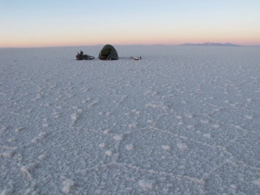

A full moon rose over the Salar.
From the closed ‘Playa Blanca’ salt hotel we had heard of another ‘terraplen’ to exit the salar maybe 10km south of Colchani and much closer to Uyuni thus saving us going to Colchani and less time on the notoriously bad road to Uyuni. We ended up overshooting (we think?) the ‘terraplen’ by a couple of kilometres and made landfall the original and difficult way, wheeling our bikes for over 2km through crumbling salt, then sand, and then over razor sharp coral rock to reach the road. It had cut off maybe 11km of bad road and Colchani so was still well worth the effort.
Uyuni
‘Terra firma’, after 3 days on the salt we rolled into the altiplano town of Uyuni which provided all the luxuries of the biggest town we had seen since La Paz including the famous ’minuteman pizza’ (thanks to Jeff Kruys who told us about this 'must eat' way back in Cartagena, Colombia!) for some well needed refueling and traveller comforts. Then it was straight to work cleaning the salt encrusted bikes. Although the Salar de Coipasa was much harder on the bikes with wet sticky salt, there was still enough salt spray to warrant the ‘full washdown’ again in Uyuni.
We are now on the ‘Bolivia detour’ by other means of transport heading to Potosi, Sucre and Santa Cruz. Anna is very interested in weaving and got in touch with Laverne Waddington , a very good weaver who lives in Santa Cruz. They are spending a few days together to work on her weaving and to learn more andean weaving techniques... More about that next post. Then we will return to Uyuni around the 10th of September, to tackle on the infamous ‘Lagunas route’ in the south-west of Bolivia.
Enjoy and thanks for following the journey
Hasta la proxima vez
Ali y Anna

Ali demonstrating the new ‘mini’ four season Hilleberg Jannu, at only a few grams, fits in your pocket and withstands strong winds!
